


As we approach a future with autonomous vehicles, smart traffic management and new uses for road infrastructure such as micro-mobility solutions, cities and towns across the world have a unique opportunity to manage the transition, influence and impact of autonomous vehicles through data control. Arguably the most challenging part for cities managing the public realm for autonomous vehicles is the curbspace and the myriad of regulations that apply in our cities for this space, or put more simply, how will autonomous vehicles know where to park?
How will Autonomous Vehicles Know Where to Park?
Tweet
Cities have been responsible for the road rules within their right of way for over a century, managing traffic speeds, intersection rules, pedestrian crossings, school zones, and restrictions on parking or stopping. In many cases, there is no record or metric of the extent or use of these rules, while there is likely a bylaw outlining the interpretation of the rules, there may not be an accurate digital representation of the areas that they apply to. In the cases where a City does have a digital representation of the rules for road use (and in particular for curbspace) in GIS mapping software, this is usually an in-house, siloed dataset used only for sign inventory management, with little consideration of Internet of Things (IoT) uses, autonomous vehicle data or smart analytics.
Parking and Regulations
When we talk about curbspace, we’re not referring to the physical curb and features such as bump outs or driveways letdowns, rather, to the regulations associated with use of the roadside space, outside of the travel lane(s). The curb regulation data not only allows autonomous vehicles to access the regulations for use in operation, but also allows cities and planners to manage competing demands for space alone the street for activities such as taxies, ride-hailing, buses, micro-mobility, fire hydrant restrictions and parking. Analysis of the data can inform policy decisions or assess the impacts of changes to a spaces’ use, such as the introduction of payment services for use of space or changing the allocation of space.
Historically, there hasn’t been a common format to store and share information about the curb. Each government agency, jurisdiction, vendor, and company approaches this problem independently and ends up developing bespoke data formats. This prevents collaboration and coordination around increasingly important public space.
SharedStreets – Medium
Recently, there has been a move to standardize curbspace data, with the introduction of the CurbLR, by Sharedstreets, an innovative open source / open data approach, which links “regulation geometry” to the digital representation of physical geometry of road spaces.
CurbLR is an open, linear-referenced data standard for curb regulations, developed by SharedStreets in partnership with Ford Mobility’s UK-based team. It provides a way for cities to collect and share curb information in a consistent format, which can then be consumed by tools, apps, and platforms.
Sharedstreets – Medium
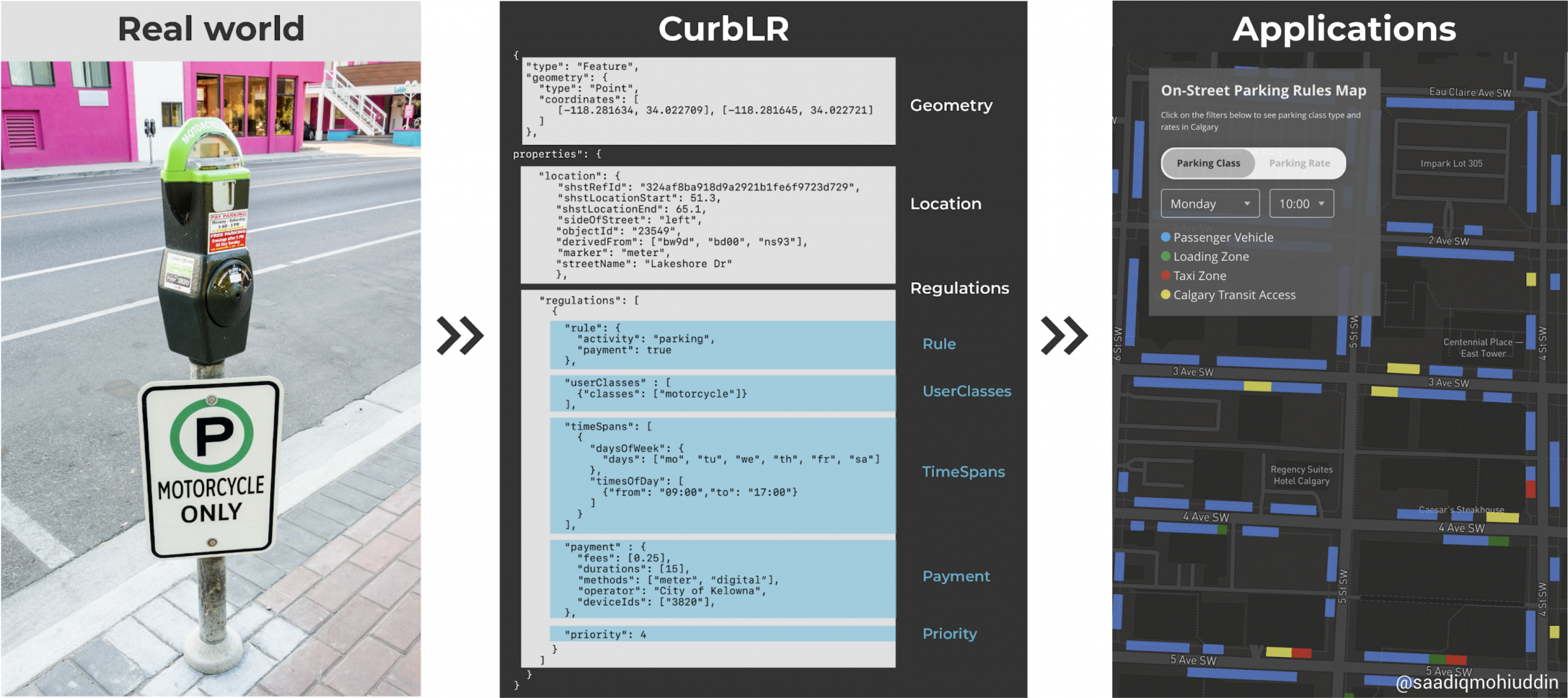
The data standard also deals with overlapping regulation geometry, detailing how they relate to each other and priority conditions.

A software solution
INRIX, a company involved in digital mapping solutions for vehicles has developed an autonomous vehicle data platform that cities can use called INRIX Road Rules, that leverages the ShareStreets open data format, to enable the creation of a geo-referenced “digital rulebook” to ensure consistency and safety for mobility and building a digital model of the road rules for traffic, parking and sidewalk use. Local governments can sign up for an account with INRIX now to access the application and start collecting information about their road right of way rules, and utilizing a framework that bridges the data gap between cities, users and technology providers.
Being ready for autonomous vehicle use in your community by creating a digital rulebook, particularly for curbspace uses will involve data collection and integration with existing GIS datasets, but can easily be tied to asset management of curb side assets such as bus stops, signage, hydrants, bikeracks, parking lane restaurant patios; or alternatively to an activity such as the study of parking space utilization.
It is exciting to see innovation in the collection and sharing of data for local governments. This is a good example of how open data formats and open government can be harnessed by industry to improve both their product and how their product is used in the real world.
